Put the Postcard Box Back on the Street
A postcard preserves a frontage. An annotated street plan places it beside a junction. A recorded recollection supplies the detail that rarely reaches a directory: which doorway people used, or where the queue formed. A neighborhood web map connects those materials through a location—while keeping each source attached to its story.
With uMap over an OpenStreetMap basemap, a small collection becomes a shareable guide without purchasing commercial map API access. For a project rooted in places & local culture, start with four to eight landmarks within a roughly 500–900-metre walking area.
The example throughout is a hypothetical former neighborhood cinema; its photographs, dates, and recollections are illustrative. Build its record around three things worth preserving together: the location, the evidence behind the description, and a portable copy of the project.
Build the Cinema’s Source Record Before Its Marker
Prepare a source index before opening the editor. A spreadsheet or text file gives every attractive photograph somewhere to acquire its credit, date, and permission record before publication.
Assign the cinema a stable identifier, cinema-01, and carry it through the marker record and media filenames. Use this compact record template:
- Identity: landmark ID and landmark name.
- Location: latitude, longitude, and former address.
- History: relevant dates and a short description.
- Evidence: source credit and reuse permission.
- Media: public image URL and audio URL.
Establish the former address from a dated directory or street plan, then compare it with surviving junctions and neighboring buildings. An advertisement documents operation at its publication date; keep that claim tied to that date.
Distinguish exact dates from estimates. An illustrative caption might read, “Approximately 1956–1958; date estimated from the donor’s annotation.” Label a resident’s account as a recollection. In sources.csv, connect each media filename to its creator, collection reference, dating information, permission record, and public address.
Keep Yesterday’s Cinema in Its Own Map Layer
OpenStreetMap supplies today’s geographic context; the uMap overlay carries the historical interpretation. Put the vanished cinema’s former entrance in that overlay, leaving the present-day street map to describe today’s streets.
- create a map in uMap and give it a neighborhood-specific name, such as “Neighborhood Landmarks: Cinema Walk.”
- Create a layer named “Landmarks” and choose a street-level basemap view.
- Begin around zoom levels 16–18. Compare the former address with surviving junctions and neighboring buildings.
- Place a marker titled “Former neighborhood cinema.” State whether it identifies the entrance or another part of the former site.
- Save the map and inspect the point at the closest useful view supported by the basemap.
For an uncertain placement, write “Approximate former entrance position” in the description. That wording makes the marker’s intended precision explicit.
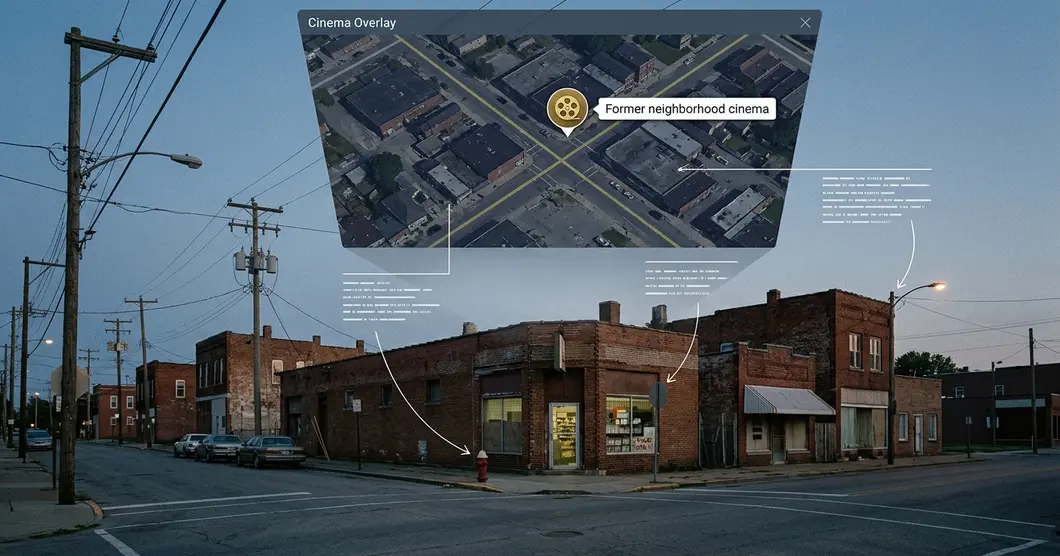
The historical marker belongs above the present-day street context, with its source information kept in the landmark record.
Give the Photograph and Spoken Memory a Clear Reading Order
Use the same sequence in every popup: landmark name, brief history, dated photograph with credit, then a clearly labeled recording link and transcript. For the cinema pilot, aim for a 40–70-word introduction and a 60–120-second recollection excerpt.
Keep original media locally. Prepare a web photograph approximately 1,200–1,600 pixels wide and a lightweight audio copy, using stable filenames such as cinema-01-exterior-web.jpg and cinema-01-memory-web.mp3. Both need publicly accessible URLs.
Insert the photograph with uMap’s supported popup formatting, {{image_URL}}, replacing image_URL with the public file address. Inspect the saved popup, including the adjacent credit and documented or estimated date.
Label the recording by subject and actual duration, then place its transcript link beside it. Record publication permission and agreed attribution for both media items. Keep private telephone numbers and email addresses out of public descriptions.
Test the Cinema Popup on a Neighbor-Sized Screen
Two marker categories answer a useful walking question: has the landmark been demolished, or does the building survive? Distinguish them with both icon shape and color, explain them in the map description, and repeat the status in popup text.
Set the opening view around the selected neighborhood, including every pilot marker with a small surrounding margin. Keep longer recollections in linked supporting material so the opening paragraph remains easy to scan.
Test the saved public map in a signed-out browser at roughly 360–430 CSS pixels wide. Open the cinema marker, read the caption, follow the recording and transcript links, and return to the map. Keep attribution visible throughout. The text history and transcript should provide complete reading paths for neighbors who choose to leave the audio unplayed.
Share the Viewing Link and Rehearse a Restore
Before distributing the map, inspect the selected instance’s account, saving, visibility, and editing controls. Share its public viewing URL; keep any secret editing URL out of neighborhood newsletters and public pages. After checking the standalone view, use the supplied embed option for an existing neighborhood webpage.
A hosted map is not permanent storage: preserve the full project export and media separately, because the export does not bundle the entire basemap or externally hosted photographs and recordings.
Download the full uMap export, commonly a .umap file, and name it with the map name and actual export date. Preserve it alongside originals, web copies, transcripts, permissions, the source index, and a readme. Record the hosting instance, public address, export date, media-folder arrangement, and restoration-test result. Keep a second copy elsewhere.
Reopen the exported project for a restoration test. Check a marker from each status category used, then open the cinema photograph, recording, and transcript. Restoring the marker and caption addresses only part of the cinema popup’s survival test; follow its media links too.
Publish One Complete Cinema Before Adding the Town
Finish the hypothetical cinema with one checked location, one credited photograph, one permission-cleared recording, its transcript, and a saved full-project export. Send the public link to a neighbor with a focused question: “Does this pin identify the public entrance, or the side service door?”
Log the response date, proposed correction, supporting evidence, and resulting edit.
Publish a carefully sourced single-landmark pilot with a tested backup before expanding the map.